9월 21일자 구글 LatLong 블로그 소식입니다. 지난 2월, 구글어스가 5.0으로 업그레이드되면서 새롭게 해양 기능이 추가되었습니다.
이와 함께 구글어스 레이어에도 별도로 "바다(Ocean)" 폴더 속에 여러 레이어가 추가되었었는데, 이중 하나의 레이어인 해양탐사(Ocean Expeditions)레이어가 갱신되었다는 내용입니다.
주요 내용으로는 여러가지 탐사선의 이동 궤적을 볼 수 있게되었다는 것과, 현재 오대양에서 탐사를 수행중인 배들의 실시간 위치도 볼 수 있게 되었다는 것 같습니다. 실시간 위치라고 해봤자 하루에 한번 정도지만요.
아래는 이 중에서 남극 주변 탐사선을 클릭해서 경로를 표시해 본 모습입니다. 오른쪽 위에 빨간 화살표가 있는 쪽이 세종기지입니다.

요즘 포스트 올리기가 점점 귀찮아지고 있습니다. 그나마 LatLong 블로그가 있으니 계속 쓰고 있지 아니었다면 벌써 잠수타고 있었을 수도 있겠다 싶네요... ㅠㅠ
민, 푸른하늘
====
http://google-latlong.blogspot.com/2009/09/desktop-discovery-following-ocean.html
Monday, September 21, 2009 at 3:50 PM
오늘 우리는 구글어스 바다(Ocean) 폴더 속에 있는 해양탐사(Ocean Expeditions)레이어를 갱신했습니다. 배 모양의 아이콘은 현재 항해중인 배에서 온 최신 포스트 혹은 최근 6개월 이내에 온 포스트(노란색 배모양)이거나, 역사적인 탐험(파란색 배모양)의 시작점에 있는 포스트입니다. 현재 내셔널 지오그래픽의 Ocean Now Pristine Seas Expedition, the Woods Hole Oceanographic Institution, Scripps Institute of Oceanography, MBARI, National Oceanography Centre, Southampton, Cousteau Society, Census of Antarctic Marine Life, 미국 National Oceanic and Atmospheric Administration (NOAA)등의 역사적 탐험 경로를 포함하여 40여개의 해양 탐사가 들어 있습니다.
우리는 최근 미국 연안경비대(
특히, 아래는 이번에 새로 추가된 실시간 탐험입니다.
====
구글 LatLong 블로그 목록 : http://heomin61.tistory.com/6
이와 함께 구글어스 레이어에도 별도로 "바다(Ocean)" 폴더 속에 여러 레이어가 추가되었었는데, 이중 하나의 레이어인 해양탐사(Ocean Expeditions)레이어가 갱신되었다는 내용입니다.
주요 내용으로는 여러가지 탐사선의 이동 궤적을 볼 수 있게되었다는 것과, 현재 오대양에서 탐사를 수행중인 배들의 실시간 위치도 볼 수 있게 되었다는 것 같습니다. 실시간 위치라고 해봤자 하루에 한번 정도지만요.
아래는 이 중에서 남극 주변 탐사선을 클릭해서 경로를 표시해 본 모습입니다. 오른쪽 위에 빨간 화살표가 있는 쪽이 세종기지입니다.
요즘 포스트 올리기가 점점 귀찮아지고 있습니다. 그나마 LatLong 블로그가 있으니 계속 쓰고 있지 아니었다면 벌써 잠수타고 있었을 수도 있겠다 싶네요... ㅠㅠ
민, 푸른하늘
====
http://google-latlong.blogspot.com/2009/09/desktop-discovery-following-ocean.html
Monday, September 21, 2009 at 3:50 PM
우리는 최근 미국 연안경비대(
- National
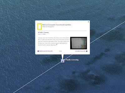
Geographic has recently begun their Ocean Now expedition to Cocos
Island in Costa Rica. From their ship blog, you can read about their mission to explore this pristine reef area, the first post from explorer Enric Sala, and you can follow their latest photos and videos in geographic context from their Expedition Maps site using Google Maps and the Google Earth plugin. Watch a video of explorer Sylvia Earle's sub dive where she met "Georgina", a hawksbill sea turtle.
- The Antinea Foundation is sponsoring the Changing Oceans Expedition, a ten-year journey through the world's most important marine areas allowing scientists to do Research, communicators to Educate and anyone to follow along virtually online. You can come along using Google Earth (download the kml pointer here) or on the expedition website, where they have the embedded Google Earth plugin. Those on the expedition will explore, study and fully share ocean discoveries, day by day, moment by moment, through this new, interactive media. Over the course of a decade the Changing Oceans Expedition ship, Fleur de Passion, will sail to 100 of the ocean's most important sites, from the shores of the Mediterranean to the farthest reaches of the South Pacific, spending 2009 in the Mediterranean Sea, the Adriatic, and in Croatia.
구글어스에서 이 km을 열고 직접 발견해 보세요. 블로그로 돌아와 보면 직접 이 탐험에 참가한 누군가의 목소리를 직접 들으실 수 있을 겁니다. - 바로 Sylvia Earle씨 입니다.

구글 LatLong 블로그 목록 : http://heomin61.tistory.com/6
2009/06/19 - 구글 해양팀 해양보전상 수상
2009/06/08 - UN에서 지정한 제1회 세계 바다의 날(Why we need to see the sea)
2008/05/19 - 구글어스로 지구 온난화를
2008/11/02 - 구글닷오알지, 지도 도전 기금 소개
2009/04/29 - 구글어스에서 흑고래의 위치를 확인하세요
2009/04/15 - 구글어스에 미국 오대호 해저지형 추가
2009/02/03 - 구글어스 5.0 탄생 - 구글 해양
2009/06/08 - UN에서 지정한 제1회 세계 바다의 날(Why we need to see the sea)
2008/05/19 - 구글어스로 지구 온난화를
2008/11/02 - 구글닷오알지, 지도 도전 기금 소개
2009/04/29 - 구글어스에서 흑고래의 위치를 확인하세요
2009/04/15 - 구글어스에 미국 오대호 해저지형 추가
2009/02/03 - 구글어스 5.0 탄생 - 구글 해양