10월 7일자 구글 LatLong 블로그 소식입니다. 구글에서 구글맵에 포함된 미국 지도를 자체 제작한 지도로 전격적으로 교체하였다는 내용입니다.
원래 구글맵에는 나브텍(Navtech)에서 제작한 지도가 사용되었으나, 꼭 1년전부터 텔레아틀라스(Tele Atlas)의 지도로 교체되었습니다.
그런데, 이번에는 미국지역에 한해서이지만 텔레아틀라스와 결별하고 자체적으로 제작한 지도를 사용하기 시작했다는 것입니다.
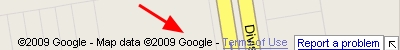
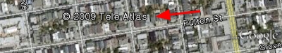
아래는 미국 샌프란시스코 지역에서 구글맵 크레딧 부분을 캡처한 것인데, Map data의 소유주가 Google이라고 표기되어 있습니다. 참고로 아래는 구글어스(Google Earth)에서 캡처한 것인데, 구글어스에는 아직도 텔레아틀라스 지도가 사용되고 있음을 알 수 있습니다.
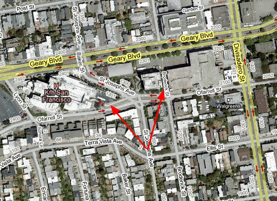
그래서 현재 이 두가지 지도를 비교해 보면 군데군데 차이가 있습니다. 아래는 동일한 지역을 비교해 본 것입니다. 복잡해 보이는 것이 구글맵 데이터인데, 더 데이터가 많네요. 뭐... 나중에 언젠가는 구글어스에 있는 도로지도도 자체 데이터로 바뀔 수도...
구글은 이 도로지도를 만들기 위해서, 여러가지 국가기관, 공공기관의 자료를 수집하여 편집하였다고 합니다. 센서스 자료, 측량자료, 산림청(USDA Forest Service)의 산림 경계, 미지질측량국(US Geological Survey)의 공원/수계자료 등을 활용했다고 하네요. 그리고 대학교 캠퍼스 지도도 추가되었고, 산책/등산로 등도 많이 추가되었다고 합니다.
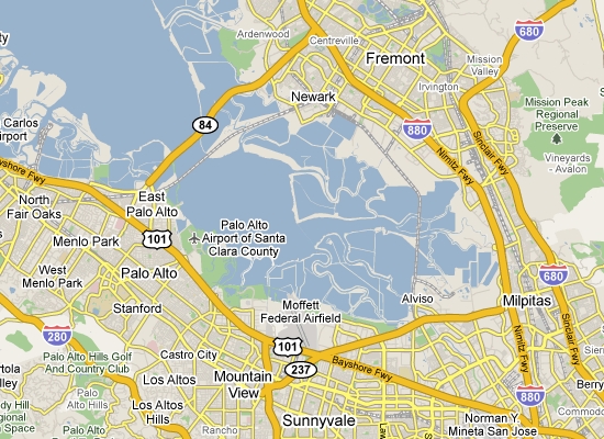
아래는 샌프란시스코 만 제일 남쪽인 마운틴뷰 인근 바다쪽인데요, 확실하게 달라졌음을 알 수 있습니다. 텔레아틀라스와 같은 도로지도 회사들은 차가 다니지 않는 곳을 저렇게 자세하게 묘사하지 않거든요.
이처럼 관련 기관으로부터 자료도 수집하는 한편, 직접 편집했다는 언급도 나옵니다. 위성사진/항공사진을 이용해 도로를 확인했다는 내용, 그리고 스트리트뷰(Street View) 영상을 이용하여 교통정보를 편집했다는 내용도 나오고요.
그런데, 구글에서 이처럼 자체적인 지도를 확보하려는 노력은 처음이 아닙니다. 2007년 11월에 잘못된 위치표지를 다른곳으로 이동시킬 수 있는 기능이 추가되었으며 2008년 3월에는 관심지점이 없다면 직접 추가할 수 있는 기능도 추가하였습니다. 저는 이런 과정을 통해 구글맵이 점점 웹 2.0 개념으로 사용자의 참여로 거듭나는 지도가 될 것이라고 생각했었는데, 정말 현실화된 것 같습니다.
하지만... 참여는 유도하지만, 공유는 아니라는 점에서 진정한 웹 2.0 개념의 지도라고 보기는 힘들겠죠. 오히려 저는 구글이 자체적으로 지도데이터를 확보하려는 의도의 일환이 아닌가 합니다. 지도의 중요성이 너무나 높기 때문에 다른 회사의 힘을 빌리기가 싫은 것이죠.
얼마전 애플에서도 도로지도 회사를 인수했다는 소식이 있었습니다. 애플 아이폰에는 현재 구글맵이 탑재되어 있으나, 위치기반 서비스를 위해서는 자체적인 도로지도가 반드시 필요하다는 인식때문이겠죠.
지도전쟁은... 우리나라 포털들 뿐만 아니라, 전세계적인 이슈입니다. 제가 보기에는 아직도 멀었습니다. 합종연횡은 앞으로 몇년 이상 계속될 것으로 보입니다.
민, 푸른하늘
====
http://google-latlong.blogspot.com/2009/10/your-world-your-map.html
Wednesday, October 7, 2009 at 8:30 AM
One of the exciting challenges of working on the Geo team at Google is that the physical world is constantly changing, and keeping on top of these changes is a never-ending endeavor. For example, 15,000 miles of roadway are built in the United States each year. At the same time, we are fortunate to have a large and active community of users who want to share detailed information about the places they live, work, and travel.
원래 구글맵에는 나브텍(Navtech)에서 제작한 지도가 사용되었으나, 꼭 1년전부터 텔레아틀라스(Tele Atlas)의 지도로 교체되었습니다.
그런데, 이번에는 미국지역에 한해서이지만 텔레아틀라스와 결별하고 자체적으로 제작한 지도를 사용하기 시작했다는 것입니다.
아래는 미국 샌프란시스코 지역에서 구글맵 크레딧 부분을 캡처한 것인데, Map data의 소유주가 Google이라고 표기되어 있습니다. 참고로 아래는 구글어스(Google Earth)에서 캡처한 것인데, 구글어스에는 아직도 텔레아틀라스 지도가 사용되고 있음을 알 수 있습니다.
그래서 현재 이 두가지 지도를 비교해 보면 군데군데 차이가 있습니다. 아래는 동일한 지역을 비교해 본 것입니다. 복잡해 보이는 것이 구글맵 데이터인데, 더 데이터가 많네요. 뭐... 나중에 언젠가는 구글어스에 있는 도로지도도 자체 데이터로 바뀔 수도...
구글은 이 도로지도를 만들기 위해서, 여러가지 국가기관, 공공기관의 자료를 수집하여 편집하였다고 합니다. 센서스 자료, 측량자료, 산림청(USDA Forest Service)의 산림 경계, 미지질측량국(US Geological Survey)의 공원/수계자료 등을 활용했다고 하네요. 그리고 대학교 캠퍼스 지도도 추가되었고, 산책/등산로 등도 많이 추가되었다고 합니다.
아래는 샌프란시스코 만 제일 남쪽인 마운틴뷰 인근 바다쪽인데요, 확실하게 달라졌음을 알 수 있습니다. 텔레아틀라스와 같은 도로지도 회사들은 차가 다니지 않는 곳을 저렇게 자세하게 묘사하지 않거든요.
이처럼 관련 기관으로부터 자료도 수집하는 한편, 직접 편집했다는 언급도 나옵니다. 위성사진/항공사진을 이용해 도로를 확인했다는 내용, 그리고 스트리트뷰(Street View) 영상을 이용하여 교통정보를 편집했다는 내용도 나오고요.
그런데, 구글에서 이처럼 자체적인 지도를 확보하려는 노력은 처음이 아닙니다. 2007년 11월에 잘못된 위치표지를 다른곳으로 이동시킬 수 있는 기능이 추가되었으며 2008년 3월에는 관심지점이 없다면 직접 추가할 수 있는 기능도 추가하였습니다. 저는 이런 과정을 통해 구글맵이 점점 웹 2.0 개념으로 사용자의 참여로 거듭나는 지도가 될 것이라고 생각했었는데, 정말 현실화된 것 같습니다.
하지만... 참여는 유도하지만, 공유는 아니라는 점에서 진정한 웹 2.0 개념의 지도라고 보기는 힘들겠죠. 오히려 저는 구글이 자체적으로 지도데이터를 확보하려는 의도의 일환이 아닌가 합니다. 지도의 중요성이 너무나 높기 때문에 다른 회사의 힘을 빌리기가 싫은 것이죠.
얼마전 애플에서도 도로지도 회사를 인수했다는 소식이 있었습니다. 애플 아이폰에는 현재 구글맵이 탑재되어 있으나, 위치기반 서비스를 위해서는 자체적인 도로지도가 반드시 필요하다는 인식때문이겠죠.
지도전쟁은... 우리나라 포털들 뿐만 아니라, 전세계적인 이슈입니다. 제가 보기에는 아직도 멀었습니다. 합종연횡은 앞으로 몇년 이상 계속될 것으로 보입니다.
민, 푸른하늘
====
http://google-latlong.blogspot.com/2009/10/your-world-your-map.html
Wednesday, October 7, 2009 at 8:30 AM
One of the exciting challenges of working on the Geo team at Google is that the physical world is constantly changing, and keeping on top of these changes is a never-ending endeavor. For example, 15,000 miles of roadway are built in the United States each year. At the same time, we are fortunate to have a large and active community of users who want to share detailed information about the places they live, work, and travel.
So,
as part of our ongoing commitment to provide the richest, most
up-to-date maps possible, we continuously explore ways to integrate new
information from users and authoritative partners into Google Maps. Two years ago, we began allowing you to move map markers to improve address precision; since early last year, you've been able to add locations; and over the past few years, we've been partnering directly with transit agencies to integrate their data.
Today
you may notice that the United States looks a bit different in Google
Maps -- all of that new green park land was probably a giveaway. That's
because we've worked directly with a wide range of authoritative
information sources to create a new base map dataset. In our
experience, these organizations that create the data do the best job of
keeping it accurate and up-to-date. For example, in the US there are a
number of publicly accessible geospatial datasets created by the
government for the Census, land surveying, and transportation. These
datasets provide information on everything from road networks and water
bodies to toll roads and bridges. By integrating this information, and
working with specialized data sources like the USDA Forest Service's Forest Boundaries and the US Geological Survey's National Hydrography Dataset, we've been able to expand and improve features in our maps like parks and water bodies.
Satellite, aerial, and Street View imagery also helped. With overhead
imagery, we could zoom in on roadway details to figure out details like
the size of the road. Our Street View imagery, which you know as a tool
to help you explore new places, turns out to be very helpful to
understand road restrictions and confirm street data by reading street
signs.
The
best part about this new dataset is that we've been able to add a lot
of new, detailed information to Google Maps - information that helps
people better explore and get around the real world. For example,
college students will be pleased to see maps of many campuses; and cyclists will now find many more trails and paths
to explore. Soon we even plan on providing you with biking directions
to take advantage of this new data. Of course, in the true Google
spirit of "launch and iterate," we plan to work with more data sources to add new features in the map.
So
where do you fit into this? Well, we've found our users are also
remarkable data sources themselves, so we've added a new tool to Google
Maps that lets you communicate directly with Google about any updates
that you think need to be made to our maps. You'll find this "Report a
Problem" link on the bottom right of Google Maps (you can also find it
by right-clicking on the map). Has that new highway on-ramp finally
opened up? Do we have an outdated name for your local school? Was Main
Street converted into a pedestrian-only walkway? Tell us! Once we've
received your edit or suggestion we'll confirm it with other users,
data sources, or imagery. We hope to resolve each edit within a month.
If you submit your email address, we'll even keep you posted on our
progress. The video below walks you through the process, or learn more here:
We're
constantly working on making sure Google Maps is up-to-date, accurate,
and includes the information that you care about most. Your edits and
feedback will not only help us achieve this goal, but will help
everyone in your community to get around town better and explore the
world.
====
====